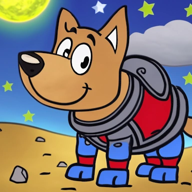
Use our free and fast online tool to convert your JPG (Joint Photographic Experts Group) image or logo into 3D XYZ (Point Cloud) mesh/model files suitable for printing with a 3D printer or for loading into your favorite 3D editing package.
Here are three simple steps to create an XYZ file from a JPG file.
This setting allows you to specify how your JPG image is converted to an XYZ model. The Extrude options will extrude your image into 3D space, while the Standard options will apply a heightmap process to your image.
The setting can be used to alter the detail of the final XYZ model that is created. The default setting of Medium works well for most Extrude and Heightmap conversions, with the High setting recommended for highly detailed image files.
This setting, when given a height of more than zero, will instruct the tool to add a solid 3D base to the final XYZ model. The selected unit of measurement specifies the height of the base.
When this option is enabled, the tool will automatically attempt to make the background of your image transparent.
Manually specify your image background color rather than our tool trying to automatically work it out.
If the tool is unable to identify the background and you know the background color, you can specify it here.
This value can be adjusted to control the background removal tolerance. The higher the value, the more background is removed.
A higher value is useful for creating smoother results if your image is anti-aliased.
When the Invert Output option is checked, the pixel brightness is reversed, i.e., black becomes white and white becomes black, resulting in a 3D model that is reversed.
This setting tells the tool how to size the final 3D model when using the settings below for Width, Height, and Depth settings.
When using either the Color Extrude or Heightmap options within the Tool menu, you can optionally upload a separate image that can be used to colorize your 3D model.
This setting instructs the tool on how to interpret the color information of pixels in your image, thereby influencing the creation of the 3D XYZ model. The grayscale option is most commonly used when working with heightmaps, unless you are dealing with specific requirements that necessitate the use of color.
Use this value to merge similar colors; this is useful if the image is of low quality. A higher number can help reduce the effects of anti-aliasing in the JPG image.
With this setting, it is possible to reduce the inclusion of small holes within the 3D model caused by small, darker areas of the source JPG file, which can be useful in situations where the source image has not been optimized for use with the tool.
When your JPG file has a transparent background, this option can instruct the tool on how to treat the transparency, with the transparency converted to either black or white.
When this setting is enabled, the conversion tool will attempt to smooth out any "spikes" within the 3D model that are caused by contrasting pixels in the image being in close proximity to one another.
With this option enabled, the tool will mirror the 3D geometry of the generated XYZ model along the Z-axis.
If you would like the tool to create a 3D preview of your model, then please select this option. It is on by default.
Use this option to generate Face or Vertex (Smooth) normals in the final 3D model. Vertex normals give the mesh a smooth appearance. You can choose to not create Normals using the None option to reduce the file size.
| Extension | JPG |
| Full Name | Joint Photographic Experts Group |
| Type | Image |
| Mime Type | image/jpeg |
| Format | Binary |
| Tools | JPG Converters, Create Cookie Cutter, JPG Viewer |
| Open With | Paint.NET, Photoshop |
The JPG file format is a popular image format most commonly used for the storage of digital photographs. The format implements a lossy-compression technology that allows for high levels of file compression with little perceptible loss of image quality, making it an ideal format for photographs.
This format is one of the most used on the internet today, with its small file sizes making it ideal for website images. Although there are newer image formats that may offer higher compression and quality, the JPG is still an ideal format for digital photos.
| Extension | XYZ |
| Full Name | Point Cloud |
| Type | 3D Model/Point Cloud |
| Mime Type | text/plain |
| Format | Text |
| Tools | XYZ Converters, 3D Model Voxelizer, Create XYZ Animation, Compress XYZ, Text to XYZ, XYZ Viewer |
| Open With | MeshLab |
The XYZ is a 3D file format used for representing 3D Point Clouds. The format contains only positional information (X, Y, and Z coordinates) for the individual points. The format is often used for digital elevation modeling of terrain for later processing in 3D modeling applications.
As the format only contains positional information, a common task is to convert this into a fully surfaced 3D model using methods such as Alpha Shapes or Delaunay Triangulation. The format can also be viewed without further processing in its raw format.
Only vertex information will be saved to the XYZ Point Cloud file generated by our tool; all other information, such as faces and material colors, will be discarded in the final file due to this information not being supported.
When creating a preview of the XYZ file, our tool will render the Point Cloud as individual squares.
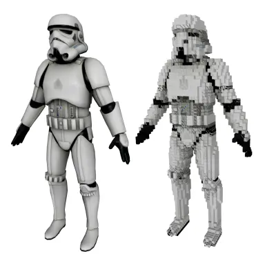
Our tool converts image (bitmap) data into 3D geometry, which is then saved to the common XYZ file format.
The JPG to XYZ tool can convert the most common image file formats, such as PNG, JPG or any one of our supported image formats. The output is provided in XYZ format, which can be used in most 3D graphics applications.
3D geometry is created based on the luminosity of each pixel in the source image. For example, using the default tool settings, a black pixel represents a 3D pixel height of 0mm, and a white pixel represents a 3D pixel height of 10mm. Colors in between these will be converted to a 3D pixel in this range.
This option reverses the black-to-white range conversion, so with this option set, a black pixel will be rendered as a 3D pixel of 10mm in height, and a white pixel will be rendered as 0mm.
The "Detail" option allows you to control the resolution of the created XYZ file. Low detail will generate the model quickly and result in a smaller file. The High option will take longer to generate and can result in very large download files.
With this option, the JPG to XYZ converter will attempt to remove or smooth out any spikes in the resulting XYZ 3D model. Spikes are usually caused by highly contrasting adjacent pixels in the source JPG file.
The JPG you upload can be any size; however, our tool will resize your image to a maximum of 1200x1200 pixels for all uploaded images that are larger than this.
First click the "Upload..." button, and select your JPG file to upload. You can also drag and drop your file onto the tool. Once your file is selected, you can set any configuration options. When the JPG to XYZ conversion has completed, you can download your XYZ file straight away.
We aim to process all JPG to XYZ conversions as quickly as possible, this usually takes around 5 seconds but can be more for larger more complex files so please be patient.
We aim to create the most accurate conversions with our tools. Our tools are under constant development with new features and improvements being added every week.
Yes, of course! We do not store the JPG file you submit to us. The resulting XYZ file, once created, is stored for 4 hours after upload; after this time it is deleted, and the short-term download link will stop working. You can create a long-term download Url with most tools that will ensure the file is retained for 24 hours, allowing you to download the file when convenient. Our tools also come with a Delete button, allowing you to delete the file immediately.
No. All our conversion tools process your JPG file on our dedicated conversion servers, meaning you can use our tools on low-spec computers, laptops, tablets, and mobile devices and receive your converted XYZ file quickly.
Yes! Our JPG to XYZ tool will run on any system with a modern web browser. No specialist software is needed to run any of our conversion tools.
Yes. Although you can use an Ad Blocker, if you like our JPG conversion tool please consider white-listing our website. When an Ad Blocker is enabled there are some conversion limits and some settings may not be available when using our tools. Processing/conversion and download times will also be longer.
Yes. When you have converted your JPG to XYZ, there is a "Feedback" option that you can use to let us know of any issues you encountered when converting your file.
© 2026 ImageToStl. Convert your PNG and JPG Files to 3D STL files.